The storm has weakened but remains a threat, with forecasters cautioning of broader East Coast impacts after two counties declared states of emergency over the weekend.
The National Hurricane Center (NHC) reported that Hurricane Erin has weakened from its peak but remains a major threat. The storm is expected to bring heavy rainfall and flooding in the Caribbean, pose risks along the U.S. East Coast, and has already triggered emergency declarations in parts of North Carolina.

Hurricane Specialist Lissa Bucci at the National Hurricane Center in Miami monitors satellite imagery of Hurricane Erin as the storm develops in the Atlantic, August 13, 2025 | Source: Getty Images
Hurricane Erin, once a Category 5 storm on Saturday, August 16, 2025, has weakened to Category 3 but remains a powerful system in the Atlantic. The NHC reported on August 17 that Erin carried sustained winds of 125 mph (205 km/h) while moving west-northwest at 13 mph (20 km/h).

Jamie Rhome of the National Hurricane Center points to Hurricane Erin’s location and intensity during a live update, showing sustained winds of 125 mph, as posted on August 17, 2025 | Source: YouTube/nwsnhc
The storm is forecast to turn northward early this week while increasing in size and strength, remaining a major hurricane through midweek.
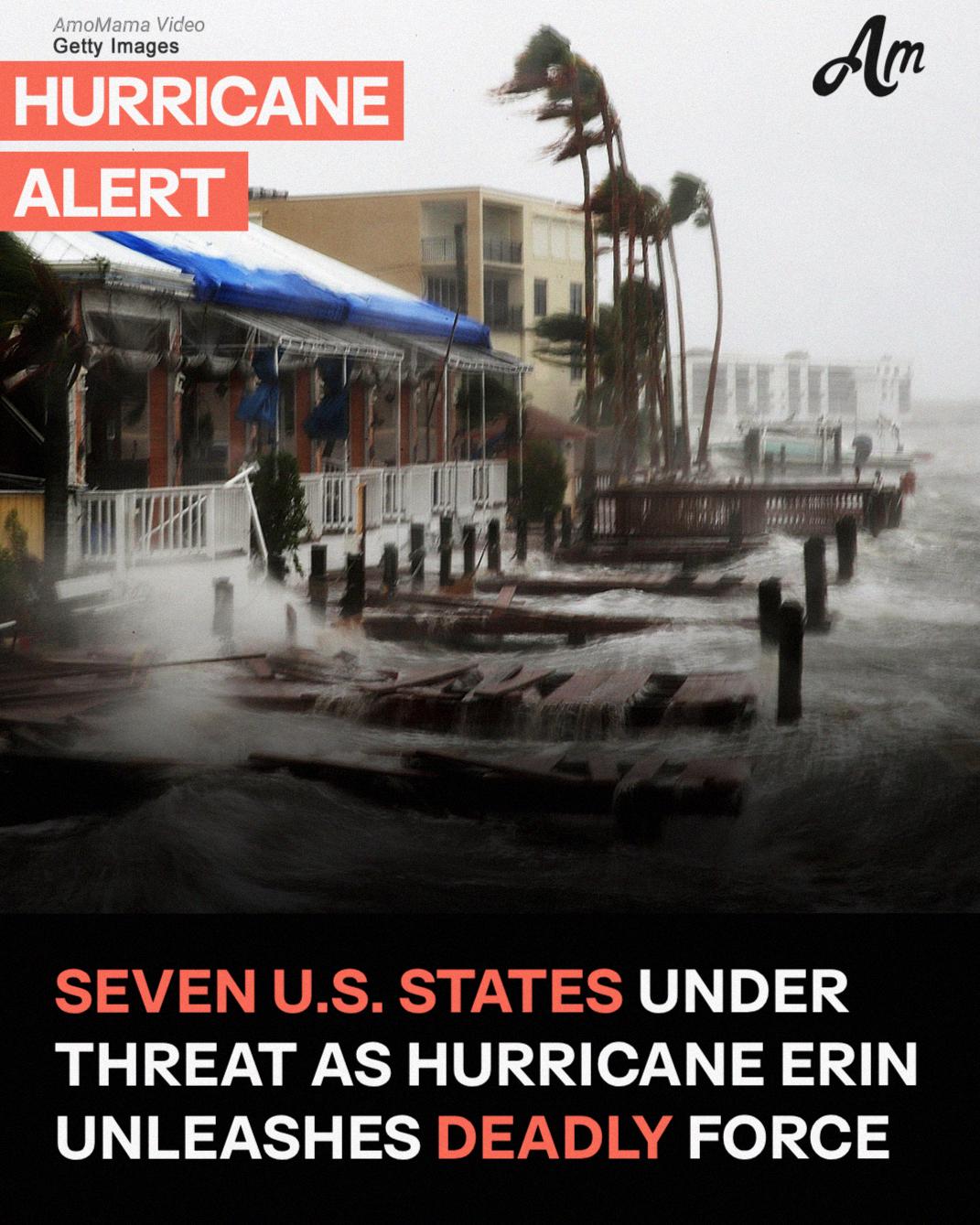
Forecasters stressed that Erin’s hazards extend far beyond its center. Hurricane-force winds stretch outward 50 miles (85 km), while tropical-storm-force winds extend more than 200 miles (335 km). The NHC warned that the storm is likely to remain “large and dangerous.”
Heavy Rainfall and Tropical Storm Warnings
Erin’s outer bands are already delivering heavy rainfall. Puerto Rico is expected to receive an additional two to four inches through Monday, while the Turks and Caicos and the eastern Bahamas, including San Salvador Island, could see up to six inches through Tuesday.

Powerful waves crash along La Pared beach in Luquillo, Puerto Rico, on August 16, 2025 | Source: Getty Images
The NHC cautioned that this rainfall could trigger flash flooding in urban areas and landslides or mudslides in mountainous terrain. Tropical Storm Warnings are in effect for the Turks and Caicos Islands and the southeast Bahamas, where conditions are expected within 24 hours.

National Hurricane Center Deputy Director Jamie Rhome delivers a live briefing on Major Hurricane Erin, highlighting Tropical Storm Warnings in the Caribbean, on August 17, 2025 | Source: YouTube/nwsnhc
In addition to rainfall, Erin’s large wind field is generating swells across much of the region. The NHC said rough seas are affecting the Virgin Islands, Puerto Rico, Hispaniola, and the Turks and Caicos, and will spread to the Bahamas, Bermuda, the East Coast of the United States, and Atlantic Canada in the coming days.
These swells are expected to produce dangerous surf and rip currents, making swimming and surfing hazardous. Minor coastal flooding is also possible in areas of onshore winds.
Potential Impacts Across the East Coast
While Erin is not expected to make landfall in the United States, its expanding size means coastal impacts will stretch for hundreds of miles. North Carolina and Virginia would reportedly face a moderate risk of rain and wind, while Florida and much of the East Coast face lower risks.
According to Newsweek, AccuWeather lead hurricane expert Alex DaSilva said, “At this time, impacts are expected to include dangerous surf, beach erosion and coastal flooding. However, conditions may worsen along the U.S. Atlantic coast, if Erin’s track shifts farther west.”
He added that coastal areas such as the Outer Banks in North Carolina, Long Island in New York, and Cape Cod in Massachusetts face the highest risk of direct impacts.
DaSilva explained that Erin has not yet begun its northward turn, and if the storm continues west before curving, the likelihood of impacts reaching the East Coast would increase.
As reported by CBS News, the Tri-State area — New York, New Jersey, and Connecticut — could feel Erin’s effects from Tuesday through Thursday, particularly along the Jersey Shore and Long Island’s South Shore.
While some outer bands may bring isolated showers, inland communities such as New York’s Hudson Valley and central New Jersey are expected to see only breezy conditions and cloud cover.
North Carolina Counties Declare States of Emergency
Local governments in coastal North Carolina have taken emergency steps ahead of the storm. After the NHC’s August 17 update, Dare County Emergency Management declared a state of emergency for all areas of the county.
The order included a mandatory evacuation for Hatteras Island, with visitors required to leave at 10 a.m. Monday, August 18, and residents at 8 a.m. Tuesday, August 19.
County officials said the evacuations are necessary despite Erin staying offshore because its expanding size is expected to deliver severe coastal impacts.
“While Hurricane Erin is expected to stay well off our coast, the system will continue to increase in size and is forecast to bring life-threatening impacts to the Dare County coastline,” the county said.
A Coastal Flood Watch is in effect, with forecasters warning that ocean overwash could make sections of N.C. Highway 12 impassable for days. Breaking waves of 15 to 20 feet are expected, capable of destroying dunes, eroding beaches, and flooding roads.
Meanwhile, the Hyde County Board of Commissioners issued a similar declaration for Ocracoke Island. The state of emergency included a mandatory evacuation for visitors effective immediately and for residents beginning Tuesday morning.
“The system will continue to increase in size and is forecast to bring life-threatening impacts to the Ocracoke coastline and render Highway 12 impassable,” the board said.
Officials warned that towering surf exceeding 20 feet could destroy protective dunes and that emergency medical services may not be available once the island is cut off. Residents with medical needs were urged to evacuate while routes remain open.
As Erin threatens offshore, Tropical Storm Chantal back in July served as a reminder of how quickly conditions can worsen along the Carolina coast.
Chantal made landfall early Sunday as a tropical storm between Charleston, South Carolina, and Wilmington, North Carolina. It was downgraded to a tropical depression shortly afterward, according to NHC and the Weather Prediction Center (WPC).
The system brought dangerous conditions to parts of the U.S. Southeast as it moved inland. As of 5 p.m. EDT, Chantal was located about 65 miles south-southwest of Raleigh, North Carolina, with sustained winds of 30 mph. It was moving north-northeast at 10 mph and was expected to accelerate toward the northeast through Monday.

Waves crash along the pier at Wrightsville Beach, North Carolina, as Tropical Storm Chantal makes landfall, posted on July 7, 2025 | Source: YouTube/ABC News
A tropical storm warning was in effect for coastal areas from the South Santee River, South Carolina, to Surf City, North Carolina, where conditions were unstable. Earlier in the day, wind gusts reached 50 mph, with sustained winds of 45 mph reported at Apache Pier in South Carolina.
Inland, flash flood watches were issued for central North Carolina and south-central Virginia, where 2 to 4 inches of rain were expected, with isolated areas receiving up to 6 inches. These amounts had the potential to cause localized flooding, particularly in urban and low-lying areas.
A tornado watch was issued for eastern North Carolina, where isolated tornadoes were possible as the storm’s rainbands moved across the region.
Along the coastline, life-threatening surf and rip current conditions continued from northeastern Florida to the Mid-Atlantic states, prompting advisories for beachgoers and coastal residents.
Forecasters tracked Chantal’s inland progression and advised residents in affected areas to monitor official updates and follow local emergency guidance.
Officials urged residents to prepare for potential evacuations and extended emergency conditions. Ready, the official emergency preparedness website of the U.S. Department of Homeland Security, encouraged individuals to first understand the specific risks facing their community.
Local hazards varied widely — from hurricanes and floods to wildfires or power outages — so officials encouraged residents to use the Federal Emergency Management Agency’s (FEMA) National Risk Index to identify the most likely threats in their area.
A key part of disaster readiness was having a clear evacuation plan in place before an emergency struck. This included selecting multiple safe destinations — such as public shelters, hotels, or the homes of friends or relatives — and identifying primary and alternate evacuation routes through local emergency management agencies. Pet owners also planned ahead, since most shelters allowed only service animals.
Equally critical was assembling a disaster supplies kit, also known as a “go-bag.” This pack included at least one gallon of water per person per day, a several-day supply of non-perishable food, a flashlight, a battery-powered or hand-crank weather radio, extra batteries, a first aid kit, and hygiene products.
Additional essential items included prescription medications, a phone charger and backup battery, important documents, cash, face masks, a manual can opener, and supplies for infants, seniors, or pets if applicable. These items should be packed in sturdy, easy-to-carry containers and stored in a location known to everyone in the household.
Ready also recommended maintaining separate kits at home, at work, and in vehicles to ensure access wherever people were when disaster struck.
Before evacuating, residents should prepare their vehicles by filling up gas tanks in advance, since stations may close or lose power during emergencies. Homeowners are advised to secure windows and doors, unplug appliances, and shut off utilities only if instructed.
When officials issued evacuation orders, residents left early to avoid being trapped by flooding or road congestion. Those without access to transportation coordinated with local officials or neighbors ahead of time.
During an evacuation, Ready advised taking the go-bag, securing the home, and following only designated routes — avoiding shortcuts, which may be blocked. Staying informed is critical: the FEMA App, available for smartphones, provides real-time alerts, open shelter locations, and hazard updates.
Officials also recommend listening to a battery-powered radio for emergency instructions. If time permits, residents should inform an out-of-state contact of their destination and leave a note at home for others.